Rooted in the Land: How Puerto Rico's Geography Gave Birth to Its Food
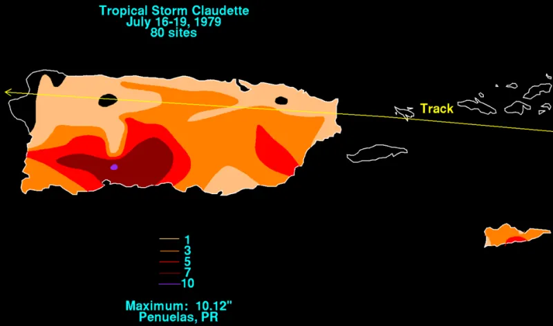
Photo: David Roth, Weather Prediction Center, Camp Springs, Maryland, Public domain, via Wikimedia Commons
When you sit down to a plate of pernil, a bowl of asopao, or a simple pile of tostones, you're not just eating food — you're eating geography. Puerto Rico's culinary identity didn't come from a cookbook. It came from soil composition, elevation gradients, ocean proximity, and centuries of people figuring out what this particular piece of land could give them. That connection between place and plate is one of the most fascinating and underappreciated stories in Caribbean geography.
Volcanic Soil and the Foundation of Flavor
Puerto Rico's agricultural history starts underground. The island sits on a foundation of volcanic and limestone rock, and the soils that developed over millions of years are remarkably fertile in certain zones. The central mountain region — anchored by the Cordillera Central — contains some of the richest agricultural land on the island. Volcanic-derived soils here tend to be deep, mineral-rich, and well-suited for crops that need consistent moisture and nutrients.
This is why coffee became so important to the island's identity. The mountainous municipalities of Yauco, Lares, and Adjuntas sit at elevations between 1,500 and 3,000 feet, where cooler temperatures slow the ripening of coffee cherries, allowing sugars to develop more fully. The combination of volcanic soil, cloud cover, and altitude creates growing conditions that coffee farmers in mainland US states simply can't replicate. Puerto Rican coffee was once considered among the finest in the world — exported to the Vatican and European royalty — and that reputation was built entirely on geographic accident.
Rain Shadows, Dry Zones, and What Grows Where
One of the most important geographic concepts for understanding Puerto Rican food culture is the rain shadow effect. The Cordillera Central acts as a barrier to moisture-laden trade winds coming from the northeast. The northeastern side of the island receives heavy rainfall — sometimes over 180 inches per year in areas like El Yunque — while the southwestern coast sits in the rain shadow and sees as little as 30 inches annually.
That contrast drives a completely different agricultural profile on each side of the island. The wet northeast and interior support dense tropical crops: plantains, bananas, yautía (taro), yuca, and breadfruit — the starchy, filling staples that became foundational to Puerto Rican cooking. These root vegetables and tropical fruits weren't chosen arbitrarily. They were the crops that thrived in the conditions the land offered.
The drier southwest, by contrast, developed different agricultural traditions. Salt production around Cabo Rojo became historically significant — the geography of shallow coastal waters and high evaporation rates made it ideal. Salt from this region preserved fish and meats long before refrigeration existed, quietly shaping the island's food preservation techniques for generations.
Coastline, Fishing Culture, and the Seafood Table
Puerto Rico has roughly 311 miles of coastline, and virtually every coastal municipality developed its own relationship with the sea. The geography of the ocean shelf matters here. The northern coast drops off sharply into deep Atlantic waters, which historically supported different fish populations than the shallower Caribbean shelf to the south.
Fishing villages along the west coast — places like Cabo Rojo, Boquerón, and Mayagüez — became known for specific seafood traditions. Boquerón's oysters are almost a regional institution at this point. The combination of mangrove estuaries, calm bay waters, and the right salinity levels created conditions where shellfish could thrive. You don't find that same tradition in Humacao or Fajardo, where the coastline and currents run differently.
The island's position in the northeastern Caribbean also made it a natural waypoint for trade routes during the colonial era. That geographic centrality meant ingredients from South America, West Africa, Spain, and eventually the United States all passed through Puerto Rican kitchens, layering flavor influences that are still visible in the sofrito-based cooking that defines so much of the island's food today.
Municipalities as Culinary Microclimates
One of the most compelling geographic stories in Puerto Rican food culture is how specific municipalities developed reputations for specific products. This isn't just local pride — it's geography expressing itself through food.
Mayagüez is famous for its breadfruit, a crop that flourishes in the warm, humid conditions of the western coast. Ponce, sitting in the drier south, developed a distinct culinary character partly because its agricultural base differed from the wetter interior. Morovis and Ciales in the central highlands are associated with root vegetables and traditional cooking styles that reflect the subsistence farming culture that highland geography encouraged.
Chorizos from certain mountain towns, guava paste from specific valleys, ñame (a type of yam) from the interior — these regional food identities aren't marketing inventions. They're the logical result of different soils, different rainfall, and different elevation profiles producing different ingredients over centuries.
The Taíno Agricultural Legacy
Before Spanish colonization, the Taíno people had already developed a sophisticated agricultural system perfectly calibrated to the island's geography. Their conuco system — mounded earth plots that improved drainage and soil aeration — was specifically designed for tropical conditions where heavy rains and poor drainage could destroy crops. The crops they cultivated, including yuca, sweet potato, corn, and various peppers, were selected because they worked with the island's geography rather than against it.
Many of those same crops remain central to Puerto Rican cooking today. Yuca shows up in pasteles, alcapurrias, and countless side dishes. The peppers that became a foundation of sofrito trace back to Taíno cultivation. Geography preserved these foods because geography made them practical — and culture kept them alive because they tasted like home.
Reading the Menu Like a Map
Next time you look at a Puerto Rican menu — whether you're visiting the island or eating at a Puerto Rican restaurant in New York, Orlando, or Chicago — try reading it like a geographic document. The plantains on your plate grew in a tropical climate that receives over 60 inches of rain annually. The coffee in your cup was shaped by altitude and volcanic minerals. The seafood in your soup came from a coastline defined by specific currents and water temperatures.
Puerto Rico's food culture is often described as a blend of Taíno, African, and Spanish influences — and that's accurate. But underneath all of that cultural history is a physical geography that made certain ingredients available and others impossible, that encouraged certain farming practices and discouraged others, and that ultimately handed cooks the raw materials they had to work with.
The island's geography didn't just set the table. It grew everything on it.