Beneath the Surface: Puerto Rico's Hidden World of Caves, Limestone, and Ancient Stone
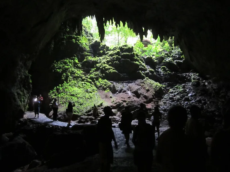
Photo: Per Aspera, CC0, via Wikimedia Commons
Puerto Rico is easy to picture above ground — the green peaks of El Yunque, the turquoise water off Flamenco Beach, the old city walls of San Juan rising above the Atlantic. But there's another Puerto Rico entirely, one that most visitors never see and most maps can't fully represent. It's the island's underground world: a vast network of caves, caverns, sinkholes, and subterranean rivers carved over millions of years through some of the most interesting geology in the Caribbean.
How Limestone Built Puerto Rico's Hidden Architecture
The story starts with the rock itself. A significant portion of northern Puerto Rico — roughly the band running from Arecibo across to Isabela — sits on a foundation of limestone, the same sedimentary rock that forms the floors of ancient shallow seas. When the Caribbean plate shifted and this seafloor was eventually pushed upward, it brought with it millions of years' worth of compressed marine sediment, now exposed as the island's karst terrain.
Karst is the geological term for landscapes shaped by the dissolution of soluble rock — mostly limestone and dolomite — by slightly acidic water. Rainwater absorbs carbon dioxide as it falls and filters through soil, becoming weak carbonic acid. Over thousands of years, this mildly acidic water slowly dissolves limestone, carving out voids, channels, and eventually full-scale cave systems underground. What you see on the surface — the rounded hills called mogotes, the collapsed sinkholes, the sudden disappearing streams — are just the visible symptoms of a much more dramatic process happening below.
Puerto Rico's karst zone is considered one of the best-developed examples of tropical karst topography in the Western Hemisphere. That's not a small claim.
Río Camuy: The Cave System That Changes Your Sense of Scale
The most famous entry point into Puerto Rico's underground world is the Río Camuy Cave Park in the municipality of Camuy, about an hour and a half west of San Juan. The cave system here is among the largest in the Western Hemisphere, carved by the Río Camuy — the third-largest underground river in the world — over the course of millions of years.
The publicly accessible sections alone are staggering. The main cavern, Clara Cave, rises to heights of over 200 feet in places, its walls draped in stalactites and its floor marked by the kind of formations that take tens of thousands of years to build. The river itself runs through portions of the system, audible before it's visible, a reminder that this isn't just a geological curiosity — it's a living, active hydrological system.
For students of physical geography, Camuy is almost an ideal field site. You can observe speleothem formations (the technical term covering stalactites, stalagmites, and related structures), understand how cave passage shapes respond to water flow, and get a tactile sense of how limestone dissolution works over geological time. For everyone else, it's just genuinely jaw-dropping.
What the Taíno Knew About the Underground
Long before geologists started mapping the karst belt, the island's indigenous Taíno people had a deep relationship with Puerto Rico's cave systems. Caves held profound spiritual significance in Taíno cosmology — they were understood as places of origin, thresholds between the living world and the realm of ancestral spirits.
The archaeological record reflects this. Dozens of caves across Puerto Rico contain Taíno petroglyphs — carved images of faces, figures, and abstract symbols etched into cave walls and ceilings, sometimes in locations that required considerable effort to reach. Cueva Ventana in Arecibo, Cueva del Indio near Arecibo's coast, and numerous less-publicized sites throughout the karst zone all preserve evidence of ceremonial use stretching back centuries before European contact.
These sites are irreplaceable. The combination of stable cave temperatures, humidity, and protection from direct weathering has preserved carvings that would have been lost long ago if exposed to the elements. In this sense, Puerto Rico's geology has functioned as an unintentional archive of indigenous culture — and the ongoing study of these sites continues to reshape what archaeologists understand about pre-Columbian Caribbean life.
Sinkholes, Water, and the Surface Consequences of Underground Geology
The relationship between Puerto Rico's cave systems and everyday life isn't purely historical or recreational. The karst terrain has real, practical consequences for water, construction, and land stability.
Because water moves through limestone via fractures and cave passages rather than filtering slowly through soil, the karst zone's aquifer system is both incredibly productive and unusually vulnerable. The Northern Karst Aquifer is one of Puerto Rico's most important freshwater sources — it supplies a significant portion of the water used by communities across the north coast. But because water moves quickly through cave passages, contaminants introduced at the surface can reach the aquifer fast, without the natural filtration that soil-based aquifers provide. Agricultural runoff, septic systems, and industrial activity all pose disproportionate risks in karst terrain.
Then there are the sinkholes. When underground cave roofs collapse — either naturally as caverns grow, or accelerated by groundwater pumping and surface loading — the ground above can give way suddenly. Puerto Rico has experienced sinkhole activity in the karst zone that has damaged roads, destabilized buildings, and reshaped local landscapes. It's a reminder that the island's geology isn't static background scenery — it's an active system that interacts with everything built on top of it.
Minerals, Metals, and What Else Lies Below
Beyond limestone, Puerto Rico's geology includes a range of mineral resources that reflect the island's complex tectonic history. The mountainous interior, particularly the older igneous and metamorphic rocks of the Cordillera Central, contains deposits of copper, gold, and iron that have attracted interest — and controversy — over the years.
Proposals to develop open-pit mining operations in the central mountains have faced significant opposition from environmental advocates and local communities concerned about impacts on watersheds, biodiversity, and the character of mountain municipalities. The debate touches directly on questions of underground geography: what lies beneath the surface, who has the right to extract it, and what the consequences might be for the water and land systems above.
That tension — between the economic potential of underground resources and the ecological value of leaving them undisturbed — is one of the defining geographic conversations happening on the island right now.
Going Deeper
Puerto Rico's underground world rewards curiosity. Whether you're a geology student trying to understand karst processes firsthand, a traveler looking for an experience beyond the beach, or just someone who wants to understand the island more fully, the caves and formations beneath the surface offer a perspective that genuinely changes how you see the landscape above. The mogotes make more sense when you understand what's carved out beneath them. The rivers mean more when you know where they disappear to. Puerto Rico, it turns out, runs a lot deeper than it looks.