Currents, Catches, and Storms: The Ocean Forces That Run Puerto Rico's World
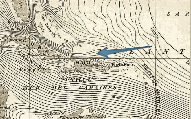
Photo: Caballero1967, CC BY-SA 4.0, via Wikimedia Commons
Most visitors to Puerto Rico spend their time looking at the island — the beaches, the rainforest, the old city walls of San Juan. But the real story? A lot of it is happening just offshore, beneath the surface, in water that never stops moving.
Ocean currents are like highways you can't see. They carry heat, nutrients, animals, and weather patterns across thousands of miles. And Puerto Rico, parked right at the intersection of the Atlantic Ocean and the Caribbean Sea, sits at one of the busiest interchanges in the Western Hemisphere. Understanding those currents is key to understanding almost everything about the island — its economy, its wildlife, its climate, and its future.
Where the Waters Meet
Puerto Rico is flanked by two very different bodies of water, and that distinction matters. To the north, the Atlantic Ocean stretches toward Florida and Europe. To the south, the Caribbean Sea connects to the Gulf of Mexico and Central America. These two bodies don't just sit there passively — they interact, and Puerto Rico is right in the middle of that interaction.
The North Equatorial Current is the big player here. It sweeps westward across the Atlantic, driven by trade winds, and splits when it hits the Caribbean island chain. Part of it feeds into the Caribbean Current, which flows northwest through the sea. Eventually, water from that system feeds into the Gulf Stream — one of the most powerful ocean currents on Earth — which carries warm water all the way up the US East Coast and across to Europe.
Puerto Rico isn't just near this system. It's embedded in it.
The Fishing Connection
For Puerto Rican fishing communities, ocean currents aren't abstract science — they're practical knowledge passed down through generations. The movement of warm, nutrient-rich water directly influences where fish gather, where they spawn, and when they migrate through Puerto Rican waters.
Species like mahi-mahi, wahoo, and yellowfin tuna follow thermal gradients — the invisible temperature boundaries where different water masses meet. These zones, sometimes called thermal fronts, act like magnets for marine life. Experienced fishermen from Cabo Rojo to Fajardo know how to read sea surface conditions, and increasingly, they're using satellite data to track those fronts in near real time.
The coral reef systems around Puerto Rico also depend on current dynamics. Currents deliver the planktonic food that reef ecosystems need, regulate water temperature, and even help disperse coral larvae to new locations. When current patterns shift — because of climate change, El Niño cycles, or other factors — reef health follows.
Hurricanes Don't Form in a Vacuum
If you've ever watched a hurricane track map, you've noticed that storms born off the coast of Africa tend to follow a fairly predictable westward path before curving north. That path is shaped in large part by the same trade winds that drive the North Equatorial Current.
Sea surface temperature is the fuel for tropical storms, and Puerto Rico's surrounding waters — warmed by those persistent currents — create conditions that can intensify hurricanes rapidly as they approach. The island sits squarely in what meteorologists call the main development region for Atlantic hurricanes.
The devastation of Hurricane Maria in 2017 is still fresh for millions of Puerto Ricans and Puerto Rican Americans. Maria didn't just hit hard because of wind speed — it hit hard because the warm Caribbean waters kept feeding energy into the storm right up until landfall. Ocean temperature data from the weeks before Maria showed abnormally warm sea surface temperatures surrounding the island. That's not a coincidence. It's oceanography.
As the planet warms, those sea surface temperatures are trending upward. Climate scientists are actively studying what that means for storm intensity in the Caribbean, and Puerto Rico is one of the most closely watched case studies.
Marine Migration Routes
The currents around Puerto Rico don't just affect local species — they make the island a waypoint for animals traveling across entire ocean basins.
Leatherback sea turtles, the largest reptiles on Earth, nest on Puerto Rico's beaches — particularly along the northeastern coast near Luquillo and in areas of Culebra — and then travel thousands of miles into the open Atlantic to feed. Their migrations follow current systems, using warm water pathways almost like a GPS.
Humpback whales pass through the Mona Passage, the channel between Puerto Rico and the Dominican Republic, during their annual migrations between feeding grounds in the North Atlantic and breeding areas in the Caribbean. The passage funnels both current flow and marine life, making it one of the most ecologically significant stretches of water in the region.
Even the Sargasso Sea — that strange, still patch of the Atlantic surrounded by currents — plays a role. American eels from rivers across the eastern US and Puerto Rico travel to the Sargasso to spawn, their larvae then carried back toward coastlines by the very currents that the adult eels swam against to get there.
Climate Resilience Starts Offshore
Here's something that doesn't get talked about enough: the ocean around Puerto Rico is also a buffer. Currents help regulate the island's temperature, moderating the extremes that a purely land-based climate would produce. The trade winds and the cool upwelling of deeper water along certain coastlines keep Puerto Rico from cooking even during the hottest months.
But that buffer is under stress. Coral bleaching events — caused by water temperatures rising just a degree or two above normal for extended periods — have hit Puerto Rican reefs hard in recent years. Bleached reefs don't just lose their color; they lose their ability to protect coastlines from wave energy, support fisheries, and attract the divers and snorkelers that fuel the tourism economy.
Policymakers and scientists are increasingly treating ocean current monitoring as a public health and economic issue, not just an environmental one. Programs at the University of Puerto Rico's marine sciences department and partnerships with NOAA are working to build better real-time models of the currents around the island — data that can inform everything from fishery management to emergency hurricane preparedness.
Why This Matters for Everyone
Whether you're a student trying to understand Puerto Rico's geography, a traveler planning a trip to the coast, or someone trying to make sense of why the island faces such compounding climate risks, the ocean currents are a thread that connects almost everything.
Puerto Rico's position within these larger ocean systems isn't a background detail — it's the central fact of the island's physical existence. The fish, the storms, the reefs, the turtles, the trade winds that made colonization possible in the first place — all of it moves through those invisible highways offshore.
Next time you're standing on a Puerto Rican beach watching the waves roll in, know that the water in front of you has traveled thousands of miles to get there. And it's carrying a lot more than salt.