Off the Grid and On the Map: What Puerto Rico's Unofficial Neighborhoods Tell Us About the Island's Real Geography
The Map You're Not Seeing
Pull up any official map of Puerto Rico and you'll find a familiar picture: 78 municipalities, clearly labeled roads, census-designated neighborhoods, and tidy boundaries separating one place from another. It looks organized. It looks complete. But spend any real time on the island — talking to people, driving through communities that don't appear on tourist guides, or just paying attention — and you start to realize the official map is leaving out a lot.
Puerto Rico has hundreds of informal neighborhoods, known locally as barrios or comunidades, that exist in a kind of geographic limbo. They're real. People live there, raise families there, build lives there. But they often sit outside formal planning systems, lack consistent utility infrastructure, and show up in census data only partially — if at all. These communities aren't anomalies. They're actually one of the most honest expressions of how geography, economics, and culture intersect on the island.
How Informal Neighborhoods Take Shape
Informal settlements don't just pop up randomly. There's a logic to where they appear, and that logic is deeply geographic.
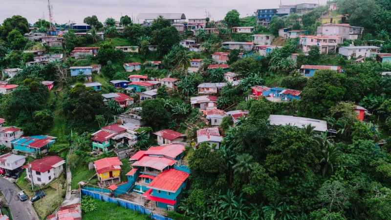
Many of Puerto Rico's informal communities developed on land that formal developers didn't want — steep hillsides above San Juan, low-lying coastal strips prone to flooding, interior valleys far from major highways. When land in desirable, well-serviced areas becomes too expensive or legally complicated to access, people find other ways. They settle on government-owned parcels that have been neglected for decades. They build on inherited family land where titles were never formally transferred. They establish communities on the edges of agricultural zones that were abandoned after the collapse of the sugar economy in the mid-twentieth century.
The result is a geographic pattern that tracks almost perfectly with economic marginalization. Communities like La Perla in Old San Juan, or the informal settlements scattered through the hillsides of Caguas and Bayamón, didn't emerge by accident. They emerged because the formal housing market wasn't built to serve everyone — and geography filled the gap.
What the Census Doesn't Capture
Here's where things get complicated for anyone trying to understand Puerto Rico through official data alone. The U.S. Census Bureau counts Puerto Rico's population, but informal communities create persistent measurement problems. Addresses don't always exist in recognizable formats. Structures built incrementally over decades don't show up in housing permits. Population density in certain hillside neighborhoods can be dramatically higher than official estimates suggest.
This matters beyond just academic accuracy. When disaster strikes — and Puerto Rico knows something about disaster — emergency response, aid distribution, and recovery planning all depend on accurate geographic data. After Hurricane Maria in 2017, some of the communities that were hardest to reach and slowest to receive help were precisely those that existed in the gaps of official mapping. The invisible map has real consequences.
Nonprofits and university researchers have spent years trying to fill those gaps, conducting community-level surveys and building alternative geographic databases. Organizations working in areas like Cataño or along the Río Grande de Loíza corridor have produced detailed maps of informal settlements that simply don't exist in any government archive. That work is ongoing, and it's increasingly urgent.
Land Titles and the Long Shadow of History
You can't understand Puerto Rico's informal geography without understanding the complicated history of land ownership on the island. Spanish colonial land grants, American territorial policies, the mid-century Operation Bootstrap industrialization push, and decades of migration patterns all left behind a tangle of unclear titles, contested parcels, and land that passed through families without ever going through formal legal channels.
In many Puerto Rican families, property has been handed down through generations based on mutual understanding rather than recorded deeds. This practice — called herencia informally — means that technically, multiple heirs may have claims to a single plot, making it nearly impossible to sell, develop, or use as collateral. People end up building on land they genuinely believe is theirs, and in a moral sense it often is, but the formal legal system doesn't recognize them clearly. That ambiguity keeps communities outside the planning grid indefinitely.
The geographic footprint of this history is visible if you know what to look for. Drive through the central mountain region — through towns like Utuado or Jayuya — and you'll see structures built on land that has been in families for over a century, with no formal address, no building permit history, and no place on an official zoning map.
Resilience Written Into the Landscape
It would be easy to frame informal neighborhoods purely as a problem — evidence of planning failure or economic exclusion. And those elements are absolutely real. But that framing misses something important about what these communities represent culturally and geographically.
Many of Puerto Rico's informal barrios are among the most tightly knit communities on the island. In the absence of formal infrastructure, residents have built their own networks — water systems improvised from shared lines, community gardens on unused lots, informal mutual aid structures that activated immediately after Maria when government response was slow. The geography of these places, their density, their physical layout shaped by relationships rather than planning codes, creates a kind of social infrastructure that formal developments often lack.
La Perla, for all the challenges it faces, has a cultural identity and community cohesion that many planned neighborhoods can't touch. The same is true of informal communities in Ponce's coastal lowlands or the hillside settlements above Río Piedras. These are places with deep roots, and their geographic character — the way they're built into the landscape rather than imposed on it — reflects that rootedness.
Reading the Real Map
For students, travelers, and anyone genuinely trying to understand Puerto Rico, the informal geography of the island is essential reading. The official map is a starting point, not the full picture. The communities that exist outside it aren't footnotes — they're often where the most authentic expressions of Puerto Rican culture and resilience are concentrated.
Geographers and urban planners increasingly talk about the need to "legalize" informal settlements — to bring them into formal systems through title recognition, infrastructure investment, and participatory planning. That process is slow, politically complicated, and often resisted by people who have good historical reasons to distrust government mapping. But the conversation is happening.
In the meantime, the invisible map keeps expanding. Every time someone builds a home on a hillside outside the formal grid, every time a community organizes around shared geography rather than official designation, the real map of Puerto Rico gets a little more complete — even if the official one hasn't caught up yet.