Storm Corridors and Settlement: The Hidden Geography That Decides Where Puerto Ricans Call Home

Photo by Photo by Beau Horyza on Unsplash on Unsplash
Most people picture hurricane danger as a simple coastline problem. Storms hit the beach, destroy homes near the water, and the rest of the island gets some wind and rain. If only it were that straightforward. Puerto Rico's actual vulnerability map looks nothing like that — it's a layered, complicated picture shaped by valleys, ridgelines, river basins, and the specific way tropical systems move across the Caribbean. And for generations, that invisible map has quietly determined where people build, where they stay, and where they keep getting hurt.
Why the Coast Isn't the Whole Story
Yes, coastal communities face real risks — storm surge, saltwater flooding, erosion. Those threats are well documented and, increasingly, well publicized. But the geography of hurricane damage in Puerto Rico extends far beyond the shoreline in ways that standard risk maps often miss.
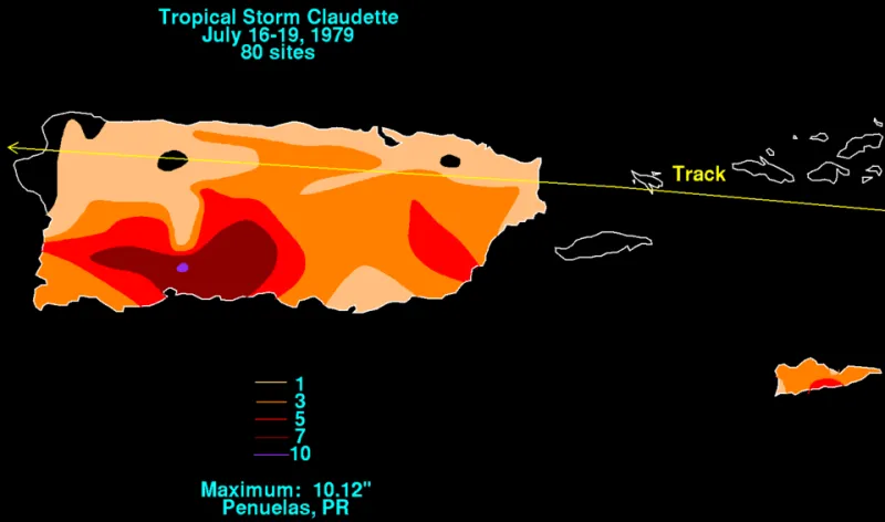
The island's central mountain range, the Cordillera Central, acts like a spine that splits incoming weather systems. When a hurricane approaches from the east — the most common track — its bands of rain get forced upward along the eastern slopes. That orographic lift squeezes moisture out of the atmosphere at a staggering rate. Communities on the eastern and northeastern flanks of the mountains, places like Humacao, Naguabo, and parts of Caguas, sit directly in zones where rainfall totals during major storms can dwarf what coastal areas experience. During Hurricane Maria in 2017, some interior eastern communities recorded over 30 inches of rain in less than 48 hours. That's not a coastal problem. That's a mountain geography problem.
Valley Corridors and the Wind Tunnel Effect
Then there are the valleys. Puerto Rico's terrain channels wind in ways that dramatically amplify storm intensity in specific corridors. Several of the island's river valleys — particularly those oriented roughly east to west — essentially act as natural funnels. When hurricane-force winds align with these valleys, they accelerate. Residents in certain inland communities can experience sustained winds significantly higher than what official measurements at coastal weather stations record, simply because of how their local topography compresses and redirects airflow.
This effect isn't well understood by most people outside of meteorology, but longtime residents in places like the Caguas Valley or parts of the Arecibo River basin have lived with it for generations. Ask older residents about past storms and they'll often describe winds that seemed impossibly strong for their distance from the coast. They weren't imagining it. The land itself was amplifying what the storm delivered.
Where Water Collects — and Stays
Rainfall concentration zones are another piece of this hidden geography. Puerto Rico's karst region in the north — that dramatic limestone landscape of sinkholes, caves, and haystack hills — creates unusual drainage dynamics. Water that falls in the karst doesn't always move quickly or predictably. It percolates, pools, and sometimes resurfaces in unexpected places. During major storms, this means certain low-lying areas in municipalities like Arecibo, Barceloneta, and Manatí flood not just from rivers overflowing their banks but from groundwater rising through the karst system from below. You can be miles from any visible water body and still end up with several feet of water in your living room.
The Rio Grande de Loíza, Puerto Rico's largest river by volume, drains a massive portion of the eastern interior. Its watershed acts as a collection basin for exactly the kind of intense orographic rainfall that major storms produce on the island's eastern slopes. Communities downstream — particularly around the Loíza municipality and the coastal lowlands near Carolina — face compounded risks: the direct storm surge from the ocean meeting the massive freshwater pulse rushing down from the mountains. It's a geographic pincer that flood models have historically underestimated.
How Risk Zones Shape Where People Live
Here's where this gets interesting from a human geography standpoint: these storm corridors have been shaping settlement decisions for a very long time, even when the people making those decisions didn't frame it that way.
Property values in Puerto Rico, when you map them against topographic risk zones, tell a revealing story. Communities repeatedly hammered by flooding tend to see long-term population loss and depressed real estate prices, which then attracts lower-income residents who have fewer housing options — creating a cycle where the most vulnerable people end up in the most vulnerable places. This pattern shows up clearly in flood-prone areas of the coastal north and in river corridor communities across the eastern interior.
Conversely, some of the island's more elevated, geographically sheltered communities — certain hillside neighborhoods in the metro San Juan area, parts of the western highlands around San Germán — carry a quiet premium that locals understand even if it's rarely spelled out in a real estate listing. Elevation and geographic position relative to storm tracks are priced into Puerto Rican property markets in ways that are more intuitive than explicit.
Storm Surge Amplification Points
Along the coast, the geometry of bays and inlets creates specific surge amplification zones that aren't obvious from a simple map. Bays with narrow mouths, like parts of the San Juan Bay system, can funnel storm surge into higher peaks than open coastlines experience. The southeastern coast, which faces the most common approach direction of Atlantic hurricanes, has several shallow coastal shelf areas where surge builds height quickly as it approaches shore.
San Juan's extensive lagoon system — connected waterways including the Condado Lagoon and the San José Lagoon — creates an urban vulnerability that's unique. These bodies of water can receive surge from multiple directions simultaneously, turning what might be a manageable coastal flood event into something that penetrates deep into densely populated urban neighborhoods.
What Better Maps Could Mean
The practical implication of all this is significant. Puerto Rico's disaster planning and building codes have historically been organized around relatively simple flood zone designations that don't fully capture the complexity of the island's hurricane geography. Newer modeling tools — combining high-resolution topographic data, historical storm track analysis, and rainfall pattern data — are starting to produce more nuanced risk pictures.
For residents, this kind of granular geographic knowledge can be genuinely life-changing. Understanding that your specific valley amplifies wind, or that your neighborhood sits in a karst drainage zone, or that you're downstream from a major watershed that turns into a firehose during tropical systems — that's the kind of local knowledge that informs real decisions: whether to shelter in place or evacuate, where to build a new home, whether to invest in flood mitigation for a property.
Puerto Rico has always been shaped by its relationship with tropical weather. The mountains, the valleys, the rivers, the karst — all of it exists in a constant negotiation with the storms that roll through the Caribbean. The more clearly residents and planners can read that invisible map, the better positioned the island becomes to absorb whatever the Atlantic sends next.